Three-in-one solution for managing, viewing and sharing built environment 3D data
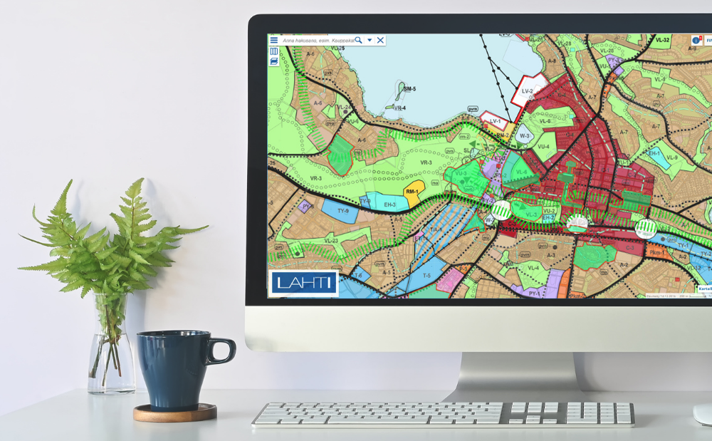
Trimble Locus is a solution for local government to manage built environment data in 3D. The solution provides all necessary tools for 3D geospatial data management and map production.
Cartographic capabilities range from detailed base maps to tourist guide maps, which can be printed or distributed through a wide range of interfaces.
3D city models
High-quality geospatial data can be maintained in both 2D and 3D views, which enables the cities to extend their base maps into up-to-date, 3D city models. Data and models from different sources can be combined and used together, e.g. GIS, BIM, InfraBIM and Lidar data. A 3D city model can be created with only one click by utilizing the buildings and terrain model produced in connection with the city base map.
When city models are enriched by information about land parcels, buildings, infrastructure and even citizen and services, a complete digital twin of the city is created. All information is managed as logical objects and the maintenance of geospatial and attribute data is possible at the same time.
Easy integration
Trimble Locus enables maintaining and viewing municipal basic registers through an integration with register data contents. The solution supports interoperability through common map formats and standard interfaces to, for example, document management and ERP systems (Enterprise Resource Planning).
Trimble Locus supports the following applications:
Land Use Planning
Street and Park Management
Trimble NIS
For documenting and managing your utility network assets.
Trimble NIS is a network information system for water, gas and district heating utilities’ business operations. Intelligent network model with integrated GIS functionality and a core functionality for documenting and managing network assets are central to the system. Elementary concepts such as topology and life cycle support for network objects are built-in properties of the model.
Trimble NIS contains several modular industry applications:
Maintenance
Asset Management
Network Calculations
Network Investment Management.
Manage electricity distribution network assets with a digital twin of your network
Trimble NIS is a Network Information System for documenting and managing utilities’ network assets. It provides a comprehensive view of a utility’s physical network by creating an intelligent virtual model – a digital twin- of the network with integrated GIS, network topology, and support for asset lifecycle management.
Over time, this intelligent network model accumulates data about assets, their structure, location, and operation, and becomes the exact digital replica of a utility’s physical network. On the top of that data, Trimble NIS uses intelligent applications for
Investment planning and analysis
Network design and technical planning
Asset maintenance
Trimble NIS holds the key to superior asset lifecycle management and optimal decision making through combining the network digital twin with CIS, EAM/AMS, and ERP.
Need Help With Easier Industrial Solutions? We Are Experts!